[Mauritania] Grand Mosque of Chinguetti
Yann2
World Monuments Fund page :
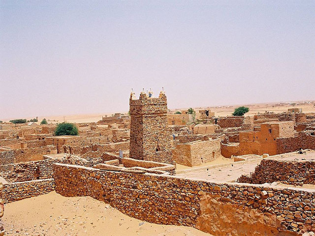
"Surrounded and sometimes nearly engulfed by the shifting dunes of the western Sahara, Chinguetti was established in the thirteenth century and is considered one of Islam's seven holy cities. A World Heritage Site, the town flourished in the Middle Ages, when it was a key stop for caravans carrying gold, salt, dates, and ivory across the Sahara. Chinguetti is also home to an extraordinary collection of important Islamic manuscripts. Its medieval mosque features a prayer room with four aisles, a double-niched mihrab, and a courtyard. It is best known for its massive square minaret that towers over the town. Chinguetti is located in the western Sahara and the encroaching desert is a constant concern. In addition, flash flooding and subsequent erosion also pose a danger to the building. Chinguetti Mosque was cited as an example of cultural heritage threatened by climate change in a report to the 30th session of the UNESCO World Heritage Committee in 2006. The site suffers as a result of the effects of the expanding desert, changing rainfall patterns, vegetation loss, soil erosion, and extreme temperatures. "
source : World Monuments Fund
Wikipedia page :
"The Chinguetti Mosque is a mosque in Chinguetti, Adrar Region, Mauritania. It was an ancient center of worship created by the founders of the oasis city of Chinguetti in the Adrar region of Mauritania in the thirteenth or fourteenth century. The minaret of this ancient structure is supposed to be the second oldest in continuous use anywhere in the Muslim world.
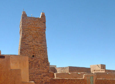
Architecturally, the structure features a prayer room with four aisles as well as a double-niched symbolic door, or mihrab pointing towards Mecca and an open courtyard. Among its most distinctive characteristics are its spare, unmortared, split stone masonry, its square minaret tower, and its conscious lack of adornment, keeping with the strict Malikite beliefs of the city's founders. The mosque and its minaret is popularly considered the national emblem of the Islamic Republic of Mauritania.
The mosque was restored through a UNESCO effort, but it, along with the city itself, continues to be threatened by intense desertification."
source : Wikipedia
Archnet reference:
"The Friday Mosque in Chinguetti was built in either the thirteenth or fourteenth century, and is said to be the soul of the holy city of Chinguetti. In the 1970s it was restored through a UNESCO effort, and though the desertification is rapidly leading to its deterioration, its minaret still towers above the old city.
The walls of the mosque are constructed of split stone and its floor is lined with sand. A roof of palm beams covered with clay is held aloft by stone piers, which, like the sanctuary at the Tomb of Askia in Mali, create four aisles of bays. The innermost aisle is set before the eastern wall of the qibla. A double-niched mihrab, which represents both the mihrab and the minbar, projects from the qibla wall, also like that at the Tomb of Askia.
Across from the mosque sanctuary in the southwestern corner of the complex, rises the dominant minaret. The minaret is notable for its lack of plaster construction. The minaret is set on a square plinth measuring between six and seven meters on each side. Rising from this base, its walls, constructed of dry yellow and rose-colored stone, taper gradually inwards to create a sawma'a tower form. The tower thickens again at the top through a triple-stepped corbelled cornice. The apex is surmounted by four pinnacle like acroteria (crenellation-like forms) at the corners.
Atop the acroteria sit clay sculptures of ostrich eggs. These ostrich eggs are said to recall a time when Chinguetti was still green and ostrich thrived there. These four pediments demarcate the four cardinal directions. A fifth egg sits in the center of the roof of the minaret, which when seen from the west defines the axis towards Mecca and serves as a guide for prayer. Supposedly in the past, travelers would give offerings of eggs at the mosque.
Small window like apertures on the west facade of the minaret allow in a slight amount of light. The larger doorway, leading to the internal minaret stairs, is surmounted by triangular ornaments.
Recent archeological findings suggest that this mosque was built upon the base of a pre-extant mosque.
source : Archnet page, on WebArchive
UNESCO World Heritage Designation :
"Founded in the 11th and 12th centuries to serve the caravans crossing the Sahara, these trading and religious centres became focal points of Islamic culture. They have managed to preserve an urban fabric that evolved between the 12th and 16th centuries. Typically, houses with patios crowd along narrow streets around a mosque with a square minaret. They illustrate a traditional way of life centred on the nomadic culture of the people of the western Sahara.
Outstanding Universal Value
Brief synthesis :
These four ancient towns, founded in the 11th and 12th centuries, were originally built to serve the important caravan trade routes that began crossing the Sahara. They comprise outstanding examples of settlements and were synonymous with cultural, social and economic life over numerous centuries. These trading and religious centres became the home of Islamic culture.
Developed between the 12th and 16th centuries, the towns constitute a series of stages along the trans-Saharan trade route with a remarkably well preserved urban fabric, and houses with patios densely-packed into narrow streets around a mosque with a square minaret. They bear witness to a traditional lifestyle, centred on the nomadic culture of the populations of Western Sahara. The medieval towns retain a specific safeguarded urban morphology with narrow and winding lanes, houses built around central courtyards and an original decorative stone architecture. They also illustrate outstanding examples of the adaptation of urban life to the extreme climatic conditions of the desert, both as regards construction methods and the occupation of space and agricultural practices.
The roots of the towns go back for more than seven centuries, resulting in urban ensembles that bear testimony to the intensity of changes linked with the important west-east and north-south trans-Saharan trade. The four towns were prosperous centres from which radiated an intense religious and cultural life. These ksour are located on the southern limits of the Saho-Sahelan desert and over time became obligatory stages for the caravan routes linking North Africa and the river regions of western Africa, but also the entire savanna zone."
source : UNESCO World Heritage site
Choice of image for stamp ?
I suggest we could consider the
Grand Mosque of Chinguetti
, as it is fairly complete and has style and a long History as an important center of worship. The town of Ouadane also has some interesting building which could provide inspiration for a stamp design.Attaching various photographs here for reference.
Also included is a very informative map of the trading routes in the Sahara and trans-sahara regions during the medieval period when the four cities were at their peak. Please visit the source links provided for more detail if desired. Thank you.
Log In
Yann2
Support new Location stamps for underserved Countries?
Dear Slowly friends,
Some of us stamp collectors decided to try to
get Location stamps
- for the many countries which still did not have ANY so far
. Many of us feel that is important, and fair with the Slowly users who live in these countries.Please check this
Reddit topic
, and see a list of currently active proposals. If you think this idea has merit, your support would be very appreciated
.An upvote, a comment in a topic are always welcome, and help ideas become reality. There are more than 25 proposals so far, and some are even in the
IN PROGRESS
stage now!I also wrote a detailed Blog post about
creating nice and successful proposals
for the Slowly Suggestions site. It could help you spruce up your own ideas and presentations here? Thank you !
Yann2
I just found a really nice page, and loved the text I am now quoting here.
Mauritania, the country
"Mauritania, situated between Morocco and Senegal, is covered for two thirds of its territory by the Sahara desert. It has less than 3 million inhabitants, mainly living on agriculture and goat and camel breeding. Today it is a poor Country, although it had been for centuries the land of nomadic people, characterized by the great routes linked to the transaharian trade and by the caravans loaded with salt and spices.
It was the Country of "the wise Bedouins", as its inhabitants like to be called still today, because already at the beginning of the second millennia the Mauri tribes had created schools, collected libraries, gathered Arabic and European intellectuals to elaborate "the thought of the desert": a symbiosis and a pact of mutual benefit between man and the Sahara was born.
The Land of Men
, as Saint Exupery, the author of The Little Prince, called it in the early 20th century. Mauritania is the country where the plane of The Little Prince has an emergency landing, and it's from those sand dunes that the child talks about his love for a unique and lonesome rose.Today, large-scale nomadism has disappeared, transaharian trades have been replaced by new, modern, and fast trade opportunities, and the ancient manuscripts have been collected in the public and private libraries of the historical towns and the capital. Chinguetti preserves
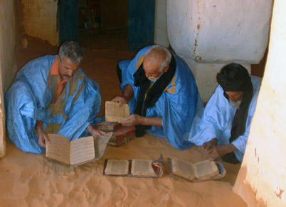
about 3,000 volumes
: almost as many as its inhabitants! Many of these volumes, if sold, would yield interesting sums for their owners (however, their sale is forbidden both by the traditional law and the penal code), but their real value is represented by the fact that they witness such a deep cultural identity that cannot even be replaced by the difficulties of the everyday survival.
Poverty, water shortage, the dunes invading the palm groves and the huge acacia trees with their roots out of the ground, as if they were leaving towards less dry lands, are the characteristic environmental features of Chinguetti plateau. The inhabitants vary from 4,000 to 6,000 according to the season, since nomadism linked to breeding activities is still practiced: the families abandon the plateau during the dry season and lead the cattle - goats and camels - to graze towards the South. Besides breeding activities, local economy also includes the production of dates, which are sold also throughout the Country, and, more recently, tourism."
source : Italy Parks
A Slowly user friend had commented to me in private that he thought the libraries of Chinguetti were important, and this confirms it. His comment :
"According to me it’s more representative the bibliotheque of chinguetti. it has immense historical value with its collection of ancient books that have miraculously survived to us. considering the environmental conditions it is something unique."
I also loved the references to St. Exupery and the Little Prince.
attachment : Oasis of Chinguetti, from site linked above.
Bajaja
All UNESCO sites I've ever been to is memorable. Maybe some of them won't be recognizable in form of a stamp, but this one looks iconically. Good idea.
Yann2
Bajaja: Thank you for your support! 👍😀😎
Nonethewiser
Beautiful place, so much history! Would look perfect as a stamp! Thank you, Yann2!
Step Hanie
Interesting place. Thank you for bringing this idea Yann2
Yann2
Step Hanie: you are very welcome, glad you found it interesting. Thank you for your support!
Yann2
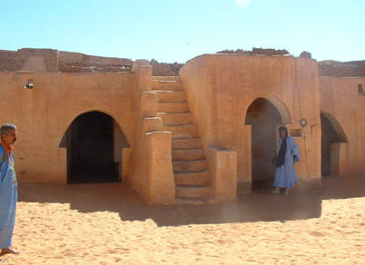
Ouadane is also UNESCO listed
And has some beautiful buildings in the old quarters, as well as some new buildings using the traditional designs and materials.
The fourth photo here is from a new town building which is very elegant.
"Ouadane or Wādān (Arabic: وادان) is a small town in the desert region of central Mauritania, situated on the southern edge of the Adrar Plateau, 93 km northeast of Chinguetti. The town was a staging post in the trans-Saharan trade and for caravans transporting slabs of salt from the mines at Idjil.
The old town, a World Heritage Site, though in ruins, is still substantially intact, while a small modern settlement lies outside its gate."
"The early history of Ouadane is uncertain but it is possible that the town prospered from the trans-Saharan gold trade. In the middle of the 11th century, the Arabic geographer al-Bakri described a trans-Saharan route that ran between Tamdoult near Akka in Morocco to Aoudaghost on the southern edge of the Sahara.[2] This route was used for the transport of gold during the time of the Ghana Empire."
Photos Source : Wikipedia