[Morocco] Tafilalt Oasis, location stamp
Yann2
Inspiration
...for this post was the photo on my Windows laptop lock-screen this morning. The photo is
Bing's Photo of the Day
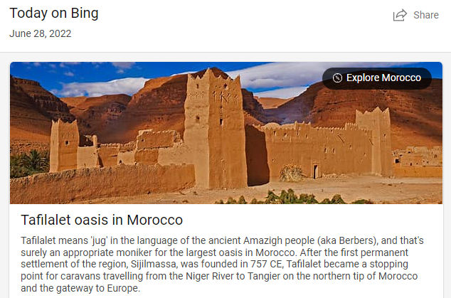
, and it is an amazing landmark, ideal for a nice Morocco location stamp.From Bing's Description
"Tafilalet means “jug” in the language of the ancient Amazigh people (aka Berbers), and that's surely an appropriate moniker for the largest oasis in Morocco. After the first permanent settlement of the region, Sijilmassa, was founded in 757 CE, Tafilalet became a stopping point for caravans travelling from the Niger River to Tangier on the northern tip of Morocco and the gateway to Europe.
The oasis here at Tafilalet thrives thanks to underground springs and wells, which are supplied by sandstone aquifers that can be hundreds of kilometres away. Surrounded by the dry sands of the Sahara, the lifegiving waters here at Tafilalet support kilometres of date palm groves, a major industry in North Africa. Over the centuries, several villages have appeared in this oasis, some of them with fortified kasbahs like this one, to withstand attacks from invaders."
source : Bing Pic of the Day
History
"Although previous settlements existed, especially during the Roman period, the first continuously inhabited town in the area after the spread of Islam was Sijilmasa, founded by the Amazigh Miknasa tribal leader Moussa ben Nasser in 757 CE.[4] It was on the direct caravan route from the Niger river to Tangier, and attained a considerable degree of prosperity.[5][6] In the 17th century, the Alaouite dynasty of Morocco first achieved political ascendancy in Tafilalt, and in 1606 the Sultan Zidan al-Nasir hid in Tafilalt, where he made a profit off of gold mined in the area, built an army, eventually taking control of the city of Marrakech.
A few years later in 1610, Ahmed ibn Abi Mahalli also built up an army in the Tafilalt area and took Marrakech back for himself, but lost control after Sidi Yahya ben Younes liberated the city for al-Nasir. A decade after this, a revolutionary movement arose in Tafilalt against the ruling sultan, but was repressed after four months of skirmishes. Later, Tafilalt was a major center of the Dila'ites.[7] In 1648, a custom was established by Moorish sultans of Morocco sending superfluous sons or daughters who would not inherit titles or power to Tafilalt.[5]
Medieval traveller Ibn Battuta wrote about visiting Sijilmasa (near Tafilalt) in the fourteenth century on his journey from Fez to Mali, "the country of the blacks".[2] It was later destroyed in 1818 by the Aït Atta, but its ruins remain, including two gateways.[8] The first European to visit Tafilalt in the modern era was René Caillié (1828), and later Gerhard Rohlfs (1864).[9][5] English writer W. B. Harris described Tafilalt in a journal after his visit."
source : Wikipedia
Rationale
Morocco currently has one single Location stamp, and its national flag. This Oasis is a major feature and source of life maintaining water in an arid region. I think the buildings and terrain shown in the photos could become a very intriguing representation of the Sahara region.
Thank you for your support, any comments or questions are welcome.
Image sources : Bing, and Desert Maroc.
Log In
Adam Be
I second this.
Yann2
Adam Be: Thank you for your support! 👍🙂
Yann2
Lovely photos, such a different place from where most of us live. Makes me think how precious water is on a place like this.
A cyclist friend who has travelled for a few years now, always on his own and with whatever his touring bike can carry, he went to Morocco. I followed his updates and was surprised many times.
Having a source of water at the end of a hot, dusty day in the sun is not only ideal, but a survival necessity. The joy when he found a place to camp with a small water source of some kind.
Lots of open spaces. Stark beauty. Extreme temperature variations, from the heat of the mid day to the cold desert night, you need to be prepared.
He told me it was the hardest trip he had ever made, and I believe it - it was my impression from following the daily posts.
Thank you for this! 🌟😎👍